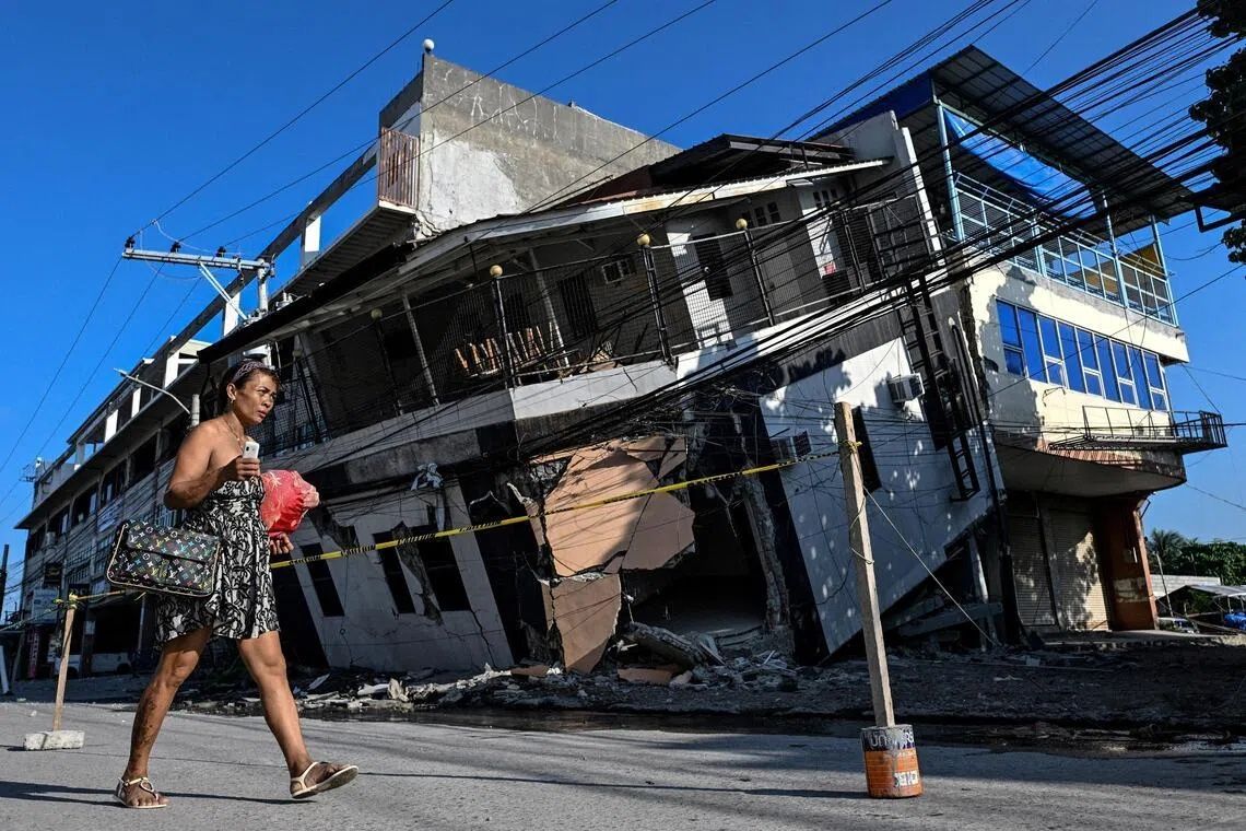
The southern Philippines experienced a geological transformation on June 8 when a 7.8-magnitude earthquake struck Mindanao, driven by tectonic shifts along the nearby Cotabato Trench. The disaster killed at least 76 people, destroyed numerous buildings, and triggered widespread landslides across the region. But beyond the immediate human toll, the earthquake left a more permanent and visually striking mark: it fundamentally altered the physical coastline, pushing submerged seabed upward and creating an entirely new shoreline that residents are struggling to comprehend.
For Arsenio Butil Jr., a fisherman and pastor living in Glan, Sarangani province, the quake was the most violent seismic event he had ever experienced. As the ground convulsed beneath him, he watched in real time as the familiar shoreline began to change before his eyes. Swathes of coral that had been underwater for generations suddenly emerged above the waterline, a phenomenon known in geological terms as coastal uplift. The transformation was so rapid and dramatic that it left witnesses like Butil Jr. initially disoriented, watching water recede and return multiple times as the earthquake's energy dissipated across the region.
What occurred geologically is explained by the movement of the Cotabato Trench, a major fault line located as close as 50 kilometres from Mindanao's coast. This trench has long been a site of intense seismic activity, and researchers had noted in a United Nations disaster risk reduction report released in mid-May that a swarm of thousands of mostly minor tremors recorded in January could potentially foreshadow a major earthquake. That warning proved prescient. The June 8 earthquake represented the violent release of accumulated tectonic pressure, forcing massive sections of the earth's crust upward in the process.
According to Nane Danlag of the Philippines' seismology centre, the seabed rose approximately two metres during the earthquake, extending the shore by up to 200 metres in some areas according to initial field assessments. The geological transformation stretches across a zone spanning nearly 100 kilometres between two towns, creating a band of new, exposed land where deep ocean once existed. Danlag emphasised that this change is permanent—residents are now looking at their new coastline, and there is no mechanism by which it will return to its previous state. Remarkably, she noted that such geological processes have been occurring for thousands of years along the Cotabato Trench, a reminder that the earth's surface is in constant, albeit usually imperceptible, flux.
Yet this geological permanence brings little comfort to displaced residents. In the hills above a neighbouring village, approximately 100 fishermen, women, and children remain encamped after fleeing to higher ground during the initial quake. Many refuse to return to their destroyed homes in the lowlands, gripped by psychological trauma and persistent fear of a potential tsunami. Datu Atom Malimpnig, a Maguindanaon chieftain, articulated the community's anxiety: the sudden emergence of new seabed had violated residents' fundamental understanding of coastal stability, replacing certainty with dread. The question haunting survivors is whether the sea might surge forward again, potentially inundating the newly raised land and claiming more lives.
The psychological impact extends beyond immediate safety concerns. For fishing communities whose entire livelihoods depend on access to the sea, the altered coastline represents an economic catastrophe. Boats that once rested at the waterline now sit stranded on the wrong side of walls of jagged, dead coral stretching for kilometres in both directions. This physical barrier has made it impossible for fishermen to launch their vessels and resume work, leaving families without income and uncertain about when—or if—they can return to their former occupations.
The tourism sector has suffered equally stark setbacks. At the Isla Jardin del Mar resort, staff member Edzel Baylon described how the newly altered landscape has decimated the destination's primary selling point. The white-sand beach that once attracted visitors to the resort is now separated from the water by exposed coral, rendering it unsuitable for swimming and water activities. What was once a picturesque shoreline has become an expanse of jagged, dead marine life—a haunting monument to the earthquake's power and a symbol of interrupted normalcy.
The sequence of aftershocks compounding residents' distress cannot be overlooked. Since the June 8 quake, more than 8,500 aftershocks have shaken the region, according to the seismology agency. Even as survivors contemplated possible rebuilding efforts, the ground continued to move beneath their feet. During a conversation with Butil Jr., who noted that cracks in the ground stretched for considerable distances and warned that the area remained dangerously unstable for reconstruction, a 5.4-magnitude tremor struck, underscoring the continued instability of the region and the practical impossibility of commencing substantial rebuilding work while seismic activity persists.
For Malaysia and the broader Southeast Asian region, the Philippine earthquake serves as a sobering reminder of the seismic hazards that characterise the Pacific Ring of Fire. The Philippines sits on one of the world's most tectonically active zones, and events like the June 8 earthquake demonstrate how rapidly geological processes can reshape entire communities and economies. Neighbouring countries in Southeast Asia, including those with significant coastal populations and fishing-dependent economies, must recognise similar vulnerabilities. The permanent nature of the Philippine coastline transformation illustrates that disaster recovery extends far beyond rebuilding structures—it encompasses fundamental reimagining of community geography and livelihoods. The reluctance of survivors to return, despite the passage of time since the initial quake, reflects the psychological trauma that geological disasters inflict, potentially displacing populations for years or permanently. As seismic monitoring technologies improve across the region, early warning systems and disaster preparedness become increasingly vital for protecting vulnerable coastal communities from both immediate earthquake impacts and their longer-term consequences.