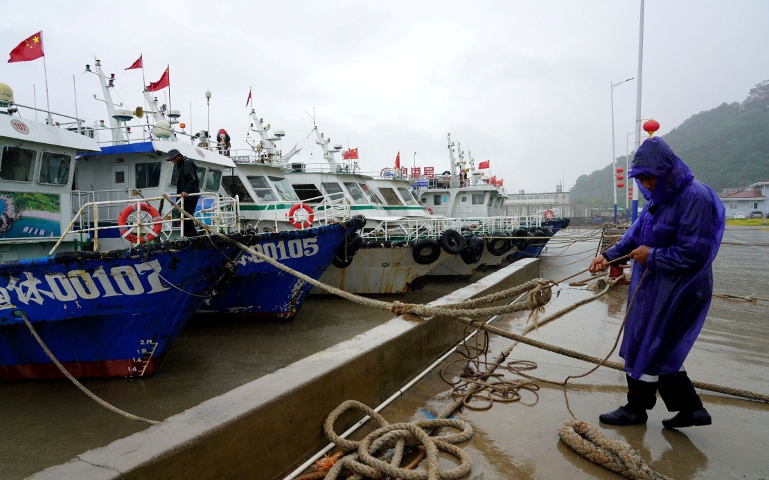
Zhejiang Province in eastern China has intensified its emergency preparations following the elevation of typhoon response measures from Level IV to Level III at midday Friday, as Typhoon Dolphin—the year's 13th tropical cyclone—draws steadily toward the Chinese mainland. The decision reflects growing concerns about the trajectory and potential impact of the storm system, which meteorological officials warn could deliver considerable damage across one of China's most economically significant regions.
As of 8 am Friday, the Zhejiang Meteorological Observatory pinpointed Typhoon Dolphin approximately 763 kilometres east of Wenling, Zhejiang, tracking westward at a measured pace of 15 to 20 kilometres per hour. Forecasters anticipate the cyclone will maintain its current strength or intensify somewhat during its approach, though the exact trajectory remains subject to atmospheric conditions that can shift unpredictably in the days ahead.
The National Meteorological Centre released a yellow-level alert Thursday evening, indicating that the storm system is expected to strike the mainland coast somewhere along the stretch separating Shanghai and Fuqing in neighbouring Fujian Province. Most projections suggest the critical landfall window will occur between Sunday and Monday, providing a narrow timeframe for final preparations and evacuation operations. Once ashore, the typhoon could escalate to severe typhoon intensity, bringing torrential rainfall and destructive winds particularly to zones lying north of the impact zone.
Lou Xiaofen, chief forecaster at the Zhejiang Meteorological Observatory, emphasised that Zhejiang faces substantial peril given its geographical position directly between Shanghai and Fujian. The province's exposed coastal geography and concentration of major ports, industrial facilities, and population centers mean that a direct strike could trigger widespread disruption across multiple sectors of the economy and infrastructure networks. The chief forecaster's assessment underscores why authorities have opted for the highest-tier alert classification.
Provincial maritime authorities have executed an extensive mobilisation of resources and personnel to mitigate disaster risks. By Friday morning, all 162 passenger ferry routes operating within Zhejiang waters had been suspended, preventing any civilian movement by sea during the dangerous window. Simultaneously, authorities instructed 193 offshore industrial and construction projects to cease operations and withdraw personnel, while summoning 474 construction vessels to port for secured anchoring. These measures represent a precautionary shutdown designed to remove human exposure from high-risk maritime zones.
The scale of the warning campaign demonstrates the seriousness with which authorities are approaching the threat. Provincial maritime authorities dispatched 86,000 early warning notifications to fishing fleets, shipping companies, port operators, and coastal residents, ensuring widespread awareness of the approaching danger. Complementing this communication push, maritime inspectors completed safety assessments of 24,000 vessels, checking moorings, supplies, and structural integrity to maximise the survivability of vessels that remain at sea. High-powered tugboats have been positioned at strategic locations along the coast, ready for immediate deployment in emergency rescue operations if needed.
For Malaysian and Southeast Asian observers, the mobilisation unfolding in Zhejiang offers instructive lessons about large-scale typhoon preparedness in a densely developed coastal region. The region's combination of sophisticated weather forecasting, coordinated inter-agency response, and resource-intensive preventive measures reflects how developed economies attempt to mitigate typhoon risks. Yet the persistent vulnerability even of economically advanced areas underscores the formidable challenge posed by tropical cyclones across Asia, a reality particularly relevant for Malaysia given its own exposure to monsoon-driven weather systems and occasional typhoon activity in the eastern regions.
Under the Level III emergency response protocols now activated throughout Zhejiang, municipal and provincial officials must intensify monitoring of the typhoon's evolving path and strength, issue regular public bulletins and forecasts, execute mandatory evacuations from high-risk coastal areas, and coordinate with local governments to ensure comprehensive guidance reaches affected populations. The framework emphasises protection of human life as the paramount objective, with economic and property considerations secondary to preventing casualties.
The designation of Typhoon Dolphin as 2026's 13th typhoon reflects what meteorologists characterise as a robust typhoon season, though specific comparisons to historical averages require more detailed seasonal analysis. The storm's positioning and projected track have elevated it to prominent status within China's weather management apparatus, triggering resource deployment and attention that illustrates how contemporary weather forecasting and emergency management infrastructure attempt to convert scientific knowledge into tangible risk reduction for vulnerable populations.
As the cyclone system continues its approach, provincial authorities face a delicate coordination challenge balancing the timing of evacuations with the precise landfall location, which remains subject to refinement as additional forecast data becomes available. The compressed preparation window between now and Sunday or Monday underscores why early escalation of alert levels remains critical in disaster management, providing populations with maximum time to reach designated shelters and for port facilities to complete their operational wind-down procedures.
The situation developing in Zhejiang will likely serve as a significant test of China's disaster management systems and inter-provincial coordination mechanisms. For the broader Asia-Pacific region, particularly maritime nations like Malaysia, Indonesia, and the Philippines, the unfolding response offers practical examples of how institutional structures attempt to translate meteorological science into life-saving operational measures when nature's most powerful systems make landfall.

