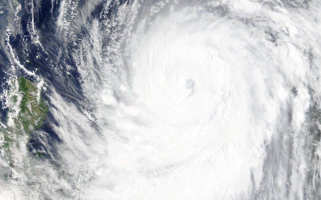
Taiwan's Central Weather Bureau escalated alert levels on Thursday afternoon as Typhoon Bavi continued its approach toward the island nation, signalling the ninth major tropical cyclone to threaten the region this year. The meteorological authority issued a formal sea warning at 2.30 pm covering vulnerable maritime zones, with officials preparing to elevate the alert to encompass land areas by early Friday morning as the system drew closer.
At the time of the warning, Bavi was positioned to the southeast of Eluanbi, Taiwan's southernmost geographical point, and tracked a northwesterly course that forecasters projected would bring the storm into closer proximity with the main island. The typhoon's strength had continued to intensify throughout the week, with meteorologists recording sustained winds near the centre reaching 51 metres per second, while peak gusts within the outer bands were measured at 63 metres per second—conditions capable of causing substantial structural damage and widespread disruption across affected communities.
The warning areas included Taiwan's northeastern and southeastern coastal waters, extending to Orchid Island and Green Island, both popular tourist destinations in the Taiwan Strait, as well as the strategically important Bashi Channel that separates Taiwan from the Philippines. These maritime zones are regularly trafficked by commercial shipping, fishing vessels, and passenger ferries, making early warning protocols essential for preventing loss of life at sea. The scope of the sea warning underscores the meteorological agency's assessment that Bavi posed a genuine and multifaceted threat to Taiwan's population and economic activities.
Based on projected movement patterns, forecasters anticipated Bavi would traverse the island's northern reaches rather than making a direct landfall across Taiwan's central or southern regions. Nevertheless, the agency cautioned that the storm would likely affect Taiwan as either a strong typhoon at the lower end of that category or as an upper-end moderate typhoon, meaning sustained impacts including heavy rainfall, flooding, and wind damage remained probable across significant portions of the archipelago. The northwestern trajectory at an estimated speed of 15 to 20 kilometres per hour suggested the system would maintain sufficient intensity while approaching and passing over or near Taiwan.
Transportation networks across Taiwan and connecting regional routes faced immediate disruption as Bavi's approach forced carriers and authorities to implement precautionary suspensions. Most commercial flight connections between Taiwan and Okinawa, a major travel corridor for business and leisure passengers, were cancelled as airlines prioritised safety over schedule adherence. Beyond the Taiwan-Okinawa route, several longer-haul international services operating from Taiwan's major airports likewise suspended operations, reflecting widespread concern about both current and forecast conditions in airspace surrounding the island.
Terrestrial and maritime transport infrastructure also experienced significant restrictions. Ferry operators suspended multiple scheduled routes connecting Taiwan to outlying islands and neighbouring ports, recognising that rough seas and gusty winds created genuine hazards for passenger vessels. Mountain roads throughout Taiwan, crucial transportation arteries for rural communities and mountain tourism, were placed on high alert status, with authorities implementing closures and restricting through-traffic where conditions deteriorated beyond safe operating parameters.
For Malaysian and broader Southeast Asian observers, Typhoon Bavi's intensification and approach to Taiwan carries implications extending beyond the immediate impact zone. Taiwan's integrated position within regional supply chains means that operational disruptions on the island can reverberate across Southeast Asian ports and manufacturing centres. The typhoon season affecting Taiwan simultaneously influences weather patterns and storm tracks affecting the wider region, including the Philippines, Vietnam, and other nations vulnerable to tropical cyclones during this period.
The timing of Bavi's approach also reflects the broader atmospheric and oceanic conditions characterising the northwestern Pacific during the July peak of the annual typhoon season. Sea surface temperatures in waters east and southeast of Taiwan remain elevated during mid-year months, providing thermal energy that fuels cyclone intensification. Understanding Bavi's development and movement patterns contributes to meteorological knowledge beneficial to forecasting services across Southeast Asia, which depend on accurate prediction of major weather systems that do not respect political boundaries.
Taiwan's meteorological preparedness demonstrated through swift warning issuance and sequential alert escalation represents the kind of institutional capacity that becomes increasingly valuable as climate patterns shift and extreme weather frequency potentially increases. The Central Weather Bureau's protocols for identifying vulnerable maritime zones and coordinating with transportation authorities provide a model relevant to other island nations and archipelagic states throughout Southeast Asia facing comparable typhoon risks and economic vulnerabilities to disruption.
As Bavi tracked northwestward toward Taiwan, residents in the projected impact zone prepared emergency supplies, secured outdoor property, and made arrangements for work or school disruptions. Fishing fleets sought shelter in protected harbours, while port authorities began implementing vessel management protocols designed to minimise damage and loss. The collective response reflected hard-earned institutional learning from decades of typhoon encounters and the scientific knowledge accumulated through modern meteorological observation networks.

