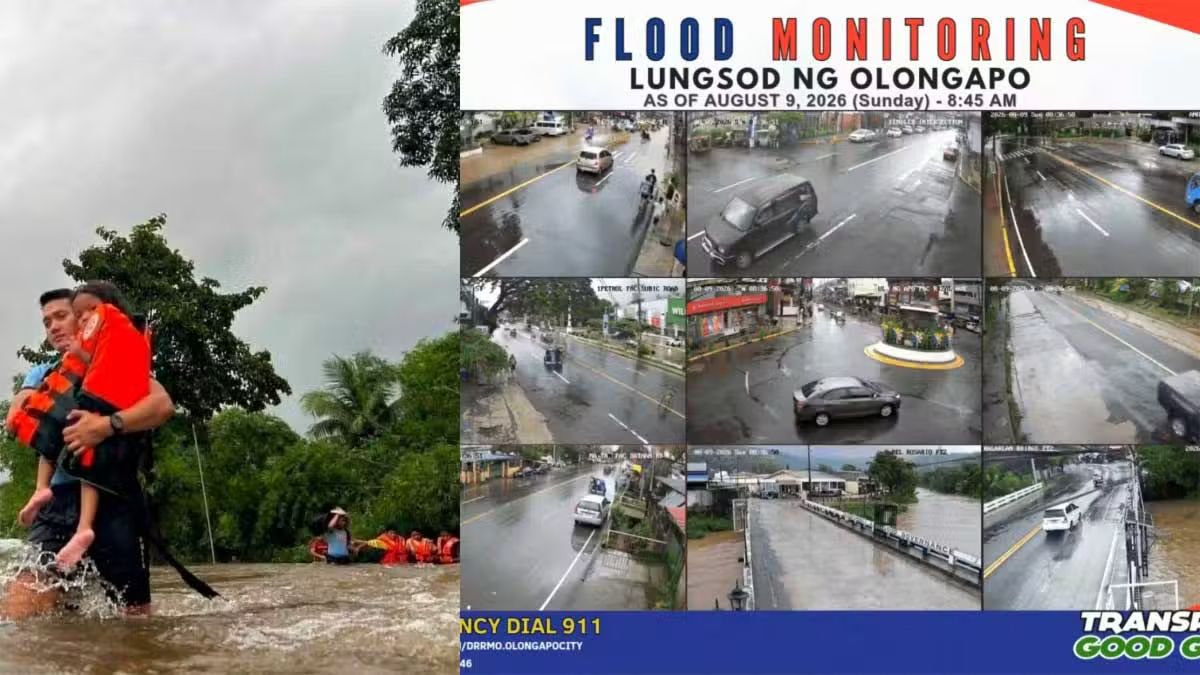
The Philippines faces an intensifying disaster as the southwest monsoon, known locally as habagat, continues to batter the archipelago, compounded by the concurrent impact of two tropical cyclones. Authorities mobilised significantly expanded rescue teams and resources across vulnerable communities on Sunday as torrential downpours forced mass evacuations from flood-prone regions. The National Disaster Risk Reduction and Management Council reported that at least 382,000 people—representing approximately 110,000 families—have been displaced or affected, with the hardest hit areas spanning eight regions concentrated in Luzon and Mindanao. The scale of the humanitarian challenge underscores the vulnerability of densely populated lowland areas and informal settlements in the face of extreme weather events increasingly intensified by climate variability.
The human cost of the disaster mounted as nine fatalities were documented, each highlighting different hazards posed by the flooding. Among the casualties was a police officer in Negros Occidental who perished while attempting a rescue operation in a swollen river, exemplifying the risks responders face during extreme weather crises. A 28-year-old resident of Cuenca, Batangas, died from electrocution while traversing a submerged section of J.P. Laurel Highway in Lipa City on Saturday evening. The remaining seven deaths stemmed from drowning incidents and landslide-related accidents distributed across multiple provinces including La Union, Pangasinan, Benguet, Ilocos Sur, and Rizal, demonstrating how the monsoon's effects span the entire northern and central portions of Luzon.
Meteorological forecasts indicate the deluge will persist through the coming week, with the Philippine Atmospheric, Geophysical and Astronomical Services Administration warning that rainfall will remain substantial through Wednesday, with particularly intense precipitation likely in elevated and mountainous terrain. The converging weather disturbances—comprising the southwest monsoon, Tropical Depression Luis, and Tropical Storm Maymay (internationally designated Kujira)—have created a compounding meteorological situation where rainfall accumulations in already-saturated areas risk triggering secondary hazards including landslides and dam overflows. The weather bureau has maintained continuous warnings since Friday, recognising that previously water-logged regions face amplified danger from additional precipitation.
Dam management has become critical as water levels surged dramatically in response to persistent rainfall. The Angat Dam in Norzagaray, Bulacan, experienced a precipitous eight-hour rise from 161.30 metres above sea level to 164.80 metres, representing the second phase of a nearly 15-metre jump over just ten days. This extraordinary escalation, which brought the reservoir from its July 30 record low of 150.61 metres above sea level, demonstrates how rapidly monsoon intensification can saturate major water infrastructure. Downstream, the Ipo Dam neared its critical 101-metre spilling threshold while discharging 314.91 cubic metres of water per second, creating cascading flood risks for communities in the lower Bulacan region where high-tide interactions compounded floodwaters that reached approximately 1.2 metres in certain localities.
Central Luzon emerged as the region suffering disproportionate damage, with 98 villages submerged and nearly 170,000 residents affected by rising waters. Pre-emptive evacuations in Nueva Ecija and Zambales relocated 781 families before conditions deteriorated further. In Zambales, the monsoon's destructive power was particularly evident where breached dikes cut off communities in San Marcelino, while strong currents destroyed a bridge in Barangay Santa Fe and violent winds damaged at least 11 residential structures and a barangay multipurpose hall in San Antonio. The Calabarzon region reported over 7,000 families displaced, with more than 3,000 families sheltering in 117 evacuation centres spread across 29 localities, straining local government resources and highlighting inadequate emergency shelter infrastructure.
Secondary impacts rippled across the northern regions where infrastructure suffered compound damage from flooding and landslide activity. Two bridges spanning the Chico River in Cagayan became impassable as water levels rose dangerously, whilst rockfalls and slope failures in Nueva Vizcaya, Abra, and Mountain Province rendered major transportation corridors unsafe. In Benguet, the municipality of La Trinidad experienced inundation approaching 0.6 metres in sections of Barangay Pico, whilst debris accumulation at the Quimmarayan River in Santo Domingo, Ilocos Sur, nearly triggered overflow before authorities cleared obstructions from beneath the Nambaran Bridge. These localised incidents collectively disrupted commerce and mobility across the northern cordillera, regions already economically challenged and now facing extended recovery periods.
Disruptions extended beyond terrestrial infrastructure to maritime operations, where the Philippine Coast Guard documented stranding of 543 passengers, commercial truck drivers, and cargo handlers across 28 ports in four separate regions. This suspension of sea transport—critical for island economies and inter-regional commerce—compounds the economic impact whilst isolating communities dependent on maritime supply chains. In Iloilo City, phenomena including a suspected tornado associated with strong monsoon winds damaged at least 52 residential structures, uprooted utility infrastructure, and displaced over 150 residents, indicating that extreme local wind effects can inflict damage rivalling primary flooding hazards.
Police leadership acknowledged the scale of emergency response requirements, with Philippine National Police chief General Jose Melencio Nartatez Jr. announcing deployment of maximum available personnel and resources for evacuation and disaster response operations. Authorities simultaneously urged residents to maintain vigilance while adhering to official guidance, cautioning against dissemination of unverified online information that could incite panic and potentially compromise organised response efforts. The emphasis on information control reflects broader challenges facing disaster management in an era of rapid social media communication, where misinformation can undermine coordinated emergency protocols.
The disaster has reignited political scrutiny regarding infrastructure adequacy and government preparedness mechanisms. Opposition legislators from the Makabayan coalition characterised the flooding as exposing systemic failures in flood control infrastructure under the current administration, particularly highlighting how the Marcos Jr. government's flood mitigation projects have proven inadequate during monsoon extremes. As the administration prepares the 2027 national budget, the coalition has called for heightened scrutiny of unprogrammed appropriations—discretionary funds that could be diverted to pork barrel schemes facilitating legislative corruption—arguing that transparent budgeting discipline could strengthen disaster preparedness investment.
For Malaysia and broader Southeast Asia, the Philippine disaster underscores the region's shared vulnerability to intensified monsoon activity and tropical cyclogenesis, phenomena increasingly linked to climate change impacts on the western Pacific. The scale and duration of Philippine flooding, affecting populations across multiple provinces simultaneously, mirrors risks confronting Malaysian states during northeast and southwest monsoon seasons, particularly in areas like Kelantan, Terengganu, and Pahang. The Philippine experience demonstrates how inadequate flood control infrastructure, informal settlement proliferation in vulnerable zones, and delayed evacuation protocols can transform predictable seasonal weather into humanitarian catastrophes. Malaysian planners and emergency management authorities may derive cautionary lessons regarding infrastructure investment adequacy and early warning implementation, particularly as climate models project intensified monsoon variability across the region through the decade.

