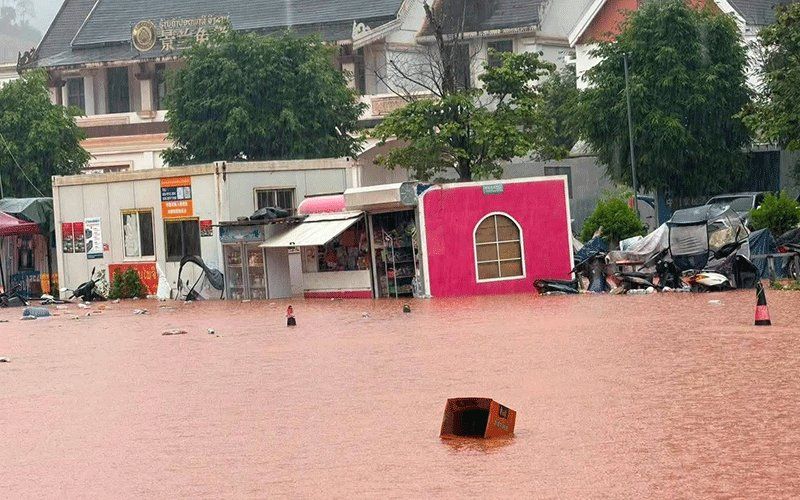
Luang Namtha province in northern Laos has been formally declared a disaster zone after torrential flash flooding swept through the region, particularly around the strategic Boten border crossing with China. The Luang Namtha Provincial Administrative Committee made the declaration on Saturday following devastating floods and landslides that ravaged the Luang Namtha and Nalae districts over a 48-hour period. The calamity has emerged as one of the most significant weather-related emergencies to strike the strategically important northern corridor in recent years, threatening both civilian lives and the economic zone that serves as a crucial trade artery between Laos and China.
The scale of destruction across the affected region underscores the severity of the deluge. More than 30 villages have been impacted by the flooding, with numerous structures near waterways either partially or completely submerged. The disaster has touched virtually every aspect of community infrastructure: residential buildings, an airport facility, educational institutions, healthcare facilities, and vast tracts of farmland have all suffered damage or inundation. The special economic zone centred around Boten, which functions as a vital commercial hub for cross-border trade and investment, experienced widespread flooding. However, the Laos-China border checkpoint itself appears to have escaped the worst of the inundation, suggesting that international trade operations could potentially resume relatively swiftly once water levels subside.
The immediate cause of this catastrophic flooding stems from a meteorological perfect storm in the mountainous terrain of northern Laos and adjacent regions of China. Multiple upstream river systems surged dramatically following several consecutive days of heavy precipitation, with water volumes swelling at unprecedented rates and flowing southward into Laos. Hydrology measurements recorded at the Tha River station demonstrated the severity of the situation: water levels reached 6.58 metres on the Saturday of the declaration, substantially exceeding the standard 6-metre flood warning threshold and creeping dangerously close to the 7-metre level that represents critical flood status. The rapidity with which water levels climbed suggests that the rainfall was both intense and widespread across the upper catchment areas, overwhelming the natural and engineered capacity of river systems to manage the volume.
The meteorological department and hydrology authorities have issued specific flood warnings for the Tha River extending through the weekend of August 29-30, signalling that conditions remain unstable and further deterioration remains possible. Recognising the ongoing danger, provincial authorities have instructed administrators across five districts to mobilise alert systems for residents situated in particularly vulnerable locations—those residing along riverbanks, in topographically depressed areas, and in other zones historically susceptible to flooding impacts. Contingency planning for potential mass evacuations has been activated, with local officials preparing to execute rapid relocation operations should water levels breach critical thresholds. The instructions issued to district officials reflect a hierarchical and coordinated emergency response framework, requiring constant monitoring of hydrological conditions, immediate response to incidents as they occur, and systematic reporting to provincial command centres to ensure situational awareness at decision-making levels.
The flooding crisis affecting Luang Namtha represents only the most acute expression of a broader weather system impacting the wider region. A low-pressure atmospheric system moving across northern Laos and into southwestern China, combined with the active southwest monsoon circulation, is creating conditions favourable for extensive precipitation and severe weather phenomena. This meteorological configuration has prompted warnings covering an expansive area encompassing 14 provinces, substantially larger than the immediately affected zone. The risk provinces span from the far north—including Phongsaly and Huaphan—through the central and southern regions including Savannakhet, Salavan, Xekong, Champasak, and Attapeu. Vientiane province, despite its more southerly location, is also included in the alert zone, indicating the extensive reach of this weather system.
The anticipated weather pattern over the weekend poses genuine risks of scattered thunderstorm development, moderate to heavy rainfall, and gusty wind conditions across the affected provinces. The convergence of distinct atmospheric systems creates conditions ripe for localised severe weather, though not all areas will experience the intensity witnessed in Luang Namtha. Emergency management authorities have issued broad-based advisories urging residents in vulnerable locations across all affected provinces to heighten vigilance, maintain awareness of meteorological forecasts, and prepare psychologically and logistically for potential evacuations should conditions deteriorate. The guidance emphasises particular caution for persons residing adjacent to watercourses and in topographical depressions, categories of population historically experiencing disproportionate impact from flash flooding and secondary hazards including landslide activity.
From a regional and economic perspective, the flooding carries implications extending beyond immediate humanitarian concerns. The Boten special economic zone represents a cornerstone of Lao-China economic integration, housing numerous commercial ventures and serving as a vital node in cross-border supply chains linking southwest China with Southeast Asia. While the border checkpoint has remained operational, disruption to the economic zone's infrastructure and logistics networks could have ripple effects throughout regional trade patterns. Malaysian and broader ASEAN trade interests that depend upon smooth functioning of this critical transit corridor should monitor the recovery situation closely, as prolonged disruption could redirect shipments and alter supply chain configurations. The location's strategic significance to regional connectivity underscores why rapid damage assessment and infrastructure rehabilitation will receive high priority in government response planning.

