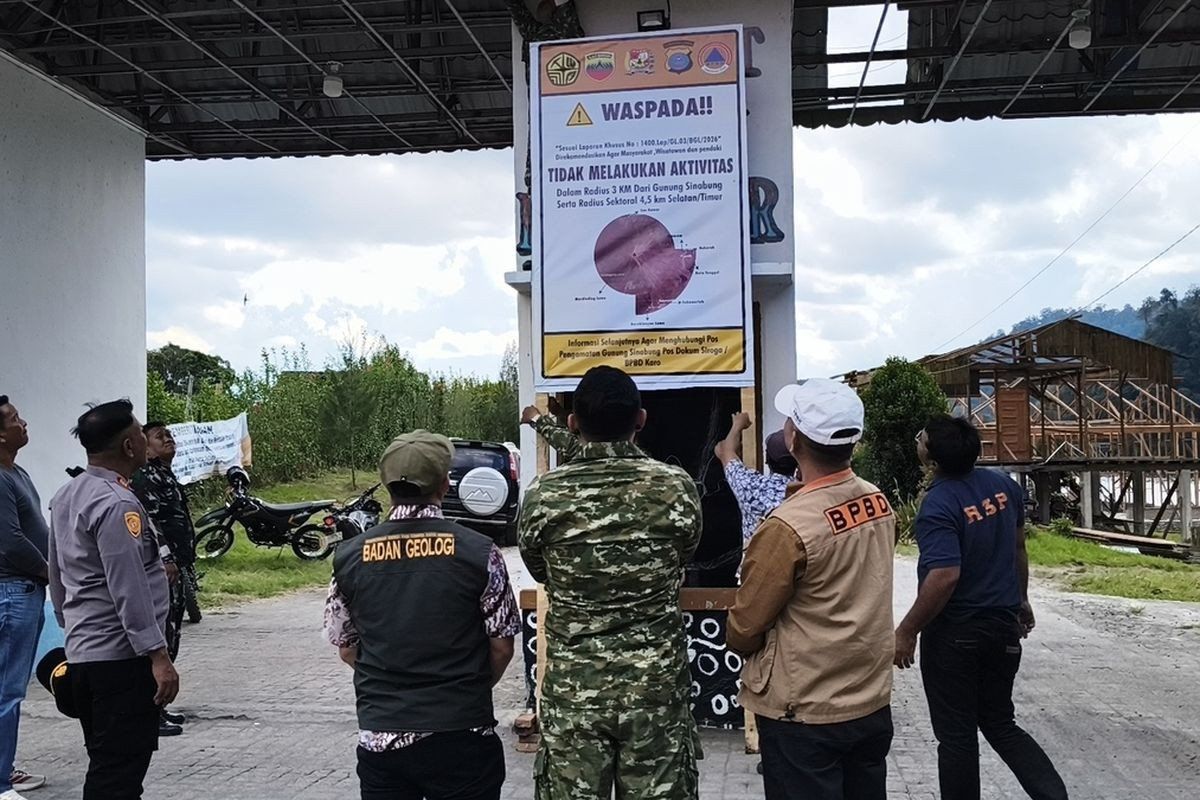
Indonesian authorities have temporarily shut down Lau Kawar Lake and associated camping facilities in Kuta Gugung village following a marked escalation in volcanic activity at Mount Sinabung, a 2,460-metre volcano in North Sumatra's Karo regency. The preventative measure took effect from August 19 and will remain in place indefinitely, according to an official directive from the Karo Youth Affairs, Sports and Tourism Agency following recommendations from the national Vulcanology and Geological Disaster Mitigation Center's monitoring command post stationed at the volcano.
The decision reflects growing concern among disaster management officials that the mountain, which sits along Indonesia's volatile Ring of Fire, poses an increasingly significant threat to nearby communities and visitors. Juni Antomi Kemit, head of the tourism agency, characterised the closure as a prudent safeguard designed to protect both residents and tourists as Mount Sinabung transitions into a heightened state of unrest. The Karo regent had issued a public advisory on August 14 explicitly instructing residents, holidaymakers, and mountaineers to refrain from any activities in the vicinity of the volcano, signalling the seriousness with which local government treats the developing situation.
Mount Sinabung's alert classification was formally upgraded from Level I (Normal) to Level II Waspada (Advisory) within Indonesia's four-tier warning system, a change that carries significant implications for the surrounding region. Armen Putra, the monitoring post commander, articulated clear safety boundaries for the region: residents and visitors should maintain a minimum distance of three kilometres from the summit, while those in the south-easterly sector should stay at least 4.5 kilometres away. Particular attention has been directed toward inhabitants living along river valleys that originate from Mount Sinabung, as these waterways present acute hazards from lahar flows—mixtures of volcanic debris and water that can travel at high speeds and cause devastating damage to settlements downstream.
The uptick in seismic activity represents the clearest indicator of the volcano's changing behaviour. During the early morning hours of August 27 alone, monitoring equipment detected five volcanic earthquakes within Mount Sinabung, alongside multiple tectonic tremors, a sharp increase from the single volcanic quake and seven tectonic quakes recorded the previous day. Visual observations have documented thick smoke plumes rising between 100 and 800 metres above the summit, whilst ground-based instruments continue recording fluctuating tremor patterns. Armen cautioned that the correlation between increased earthquake frequency and volcanic eruption potential remains a fundamental principle in volcanology; in essence, the more seismic events that occur, the greater the possibility of a major eruption.
Mount Sinabung's geological history underscores why contemporary warnings merit serious consideration. The volcano remained quiescent for approximately four centuries before its initial recorded eruption on August 29, 2010, after which it entered a prolonged phase of intermittent activity that has persisted for over a decade. Following that initial 2010 eruption, which subsequently abated in September of that year, the volcano demonstrated renewed vigour with another significant eruption in September 2013. However, it was the catastrophic November 2013 event that truly tested the region's disaster response capacity, when Mount Sinabung was elevated to Level IV Awas (Warning), the system's highest designation.
The November 2013 eruption proved particularly destructive, with pyroclastic flows—avalanches of superheated gas, ash, and rock—claiming dozens of lives whilst forcing the evacuation of approximately 21 villages and two hamlets from the danger zone. Following this traumatic episode, Mount Sinabung entered what observers termed a continuous eruption cycle spanning six years. The volcano's status was eventually downgraded to Level III Siaga (Watch) on May 20, 2019, after vulcanologists analysed both visual data and instrumental readings indicating that the immediate threat had diminished substantially. This relative quiescence, however, proved temporary.
In July 2021, the volcano resumed its destructive behaviour with renewed eruptions that projected ash columns as high as 4,500 metres into the atmosphere. The associated pyroclastic flows extended up to 1,000 metres towards the east-southeast, affecting at least five districts with blankets of fine volcanic ash that disrupted daily life across the region. That 2021 event marked the most recent major eruption before the present escalation, concluding an eleven-year cycle of active volcanism that demonstrated the volcano's capacity for sudden, severe outbursts.
The current phase of unrest carries particular significance for Southeast Asia's tourism sector, which has been gradually recovering from pandemic-related disruptions. Mount Sinabung, despite its hazards, has attracted adventure tourists and mountaineers seeking to experience Indonesia's dramatic volcanic landscape. The indefinite closure of Lau Kawar Lake, a popular destination within the volcanic region, represents not merely a temporary inconvenience but a reminder of the fragile balance between tourism development and natural hazard management in geologically active zones. For Malaysia, where volcanic activity at Mount Kinabalu and other regional volcanoes periodically generates concern, the situation at Mount Sinabung offers instructive lessons in disaster preparedness and public communication during volcanic emergencies.
Indonesian authorities have adopted a deliberately precautionary stance, recognizing that early intervention and public warnings—even if they ultimately prove unnecessary—remain preferable to underestimating volcanic hazards. The closure decision reflects international best practices in volcanic risk management, where scientific uncertainty is translated into conservative public health measures. As monitoring continues and scientists assess whether Mount Sinabung's current activity represents a temporary fluctuation or the precursor to a major eruption, the temporary tourism restrictions will almost certainly remain in effect. For the region's residents and the broader Southeast Asian community, the situation serves as a sobering reminder of the dynamic geological forces that continue to shape the archipelago.

