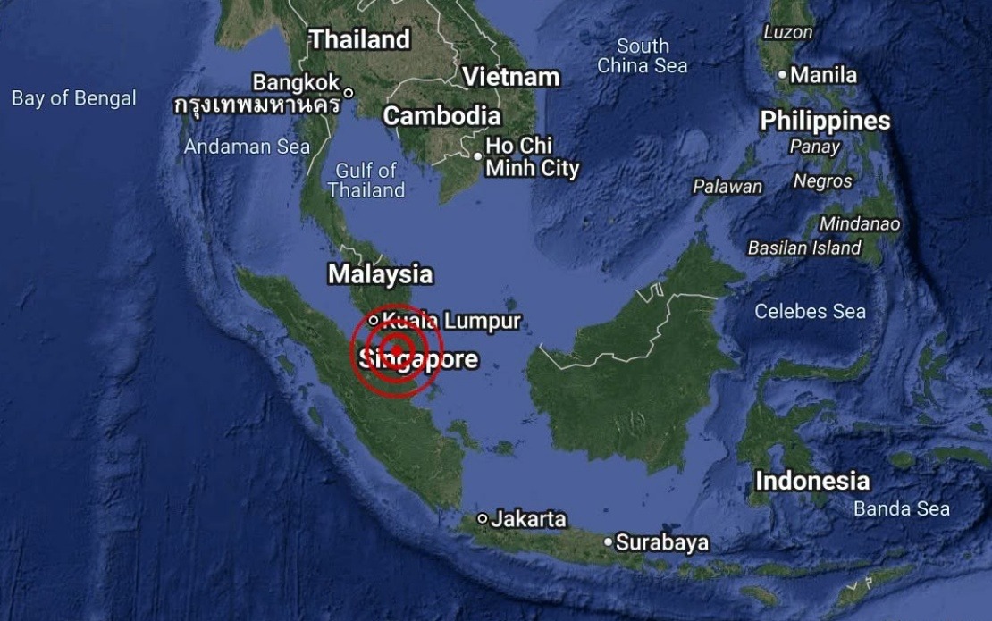
A moderate earthquake with a magnitude of 3.1 rocked the coastal waters off Batu Pahat in Johor on August 25, registering at 4.12 pm local time. The tremor, while noticeable to residents in the vicinity, remained within the range of seismic activity regularly monitored across Malaysia's maritime regions, where tectonic movements occasionally generate minor to moderate earthquakes.
According to data released by the Malaysian Meteorological Department (MetMalaysia), the earthquake's epicentre was positioned at coordinates 1.7 degrees north latitude and 102.8 degrees east longitude, placing the seismic event approximately 18 kilometres south-west of Batu Pahat town proper. The location, situated in the waters off the Johor coast rather than on land, meant that the primary impact remained confined to the marine environment with minimal direct effects on populated areas.
MetMalaysia's National Weather and Earthquake Operations Centre issued an immediate statement confirming that no tsunami threat materialized from the event. This reassurance came as part of standard protocol whenever seismic activity occurs in Malaysian waters, particularly in regions where offshore tremors could theoretically trigger wave action. The department's rapid assessment and public communication reflected established procedures for managing public safety information during earthquake events.
The 3.1-magnitude reading places this earthquake comfortably within the range of minor seismic events that occur regularly throughout the region. While perceptible to people in proximity to the epicentre, tremors of this magnitude typically cause no structural damage to buildings or infrastructure. For maritime operations in the area, including fishing vessels and commercial shipping, such events are generally considered routine aspects of maritime activity in waters adjacent to tectonically active zones.
Batu Pahat, situated along Johor's southwestern coast, exists within a broader seismic context that sees periodic earthquake activity across the Strait of Malacca and surrounding waters. The region's position relative to major tectonic boundaries means that occasional minor earthquakes represent a normal feature of the local geological environment rather than unusual or alarming occurrences. Residents and maritime workers in the area have become accustomed to such events as part of living and working near coastal waters.
The timeliness of MetMalaysia's public announcement demonstrated the importance of rapid information dissemination following seismic events. By confirming both the earthquake's occurrence and the absence of secondary hazards like tsunamis, the department helped prevent unnecessary alarm among the public and ensured that residents and workers could continue their activities with accurate information about actual risks.
For Malaysian readers and businesses with interests in Johor's maritime sector, understanding the distinction between minor earthquakes and genuine hazards remains crucial. The distinction between magnitude and potential damage, and between earthquake occurrence and tsunami risk, affects how people interpret warnings and maintain appropriate preparedness without succumbing to unwarranted anxiety. MetMalaysia's consistent approach to earthquake communication helps maintain this balance.
The incident underscores the importance of maintaining robust seismic monitoring infrastructure across Malaysia's maritime zones. As a nation with extensive coastal areas and significant maritime economic activity, Malaysia benefits substantially from MetMalaysia's continuous surveillance of seismic activity. This monitoring capacity enables rapid public notification and supports decision-making by maritime authorities and operators who need accurate, timely information about geological hazards.
For the broader Southeast Asian region, individual earthquake events like those off Batu Pahat contribute to a cumulative understanding of seismic patterns and geological processes. The region's position relative to major tectonic systems means that coordinated earthquake monitoring and information-sharing among regional meteorological agencies enhances overall maritime safety and public preparedness. Malaysia's participation in these systems strengthens disaster management capabilities across neighbouring countries as well.
Looking forward, continued investment in earthquake monitoring technology and public education about seismic hazards remains valuable for Malaysia. While most earthquakes recorded in Malaysian waters pose minimal risks, maintaining awareness and preparedness ensures that when more significant events do occur, public response mechanisms function effectively. The August 25 event serves as a routine reminder of the importance of these ongoing efforts.

