Japan's meteorological authorities issued urgent warnings Friday of an impending dual-typhoon event that could strike the archipelago over the weekend, forcing evacuation of more than two million residents across thirteen prefectures. The Japan Meteorological Agency identified two distinct systems—Typhoon Higos approaching from the Pacific and Typhoon Mekkhala already moving toward the nation's southwestern territories—as simultaneous threats that would compound rainfall and wind dangers across multiple regions simultaneously.
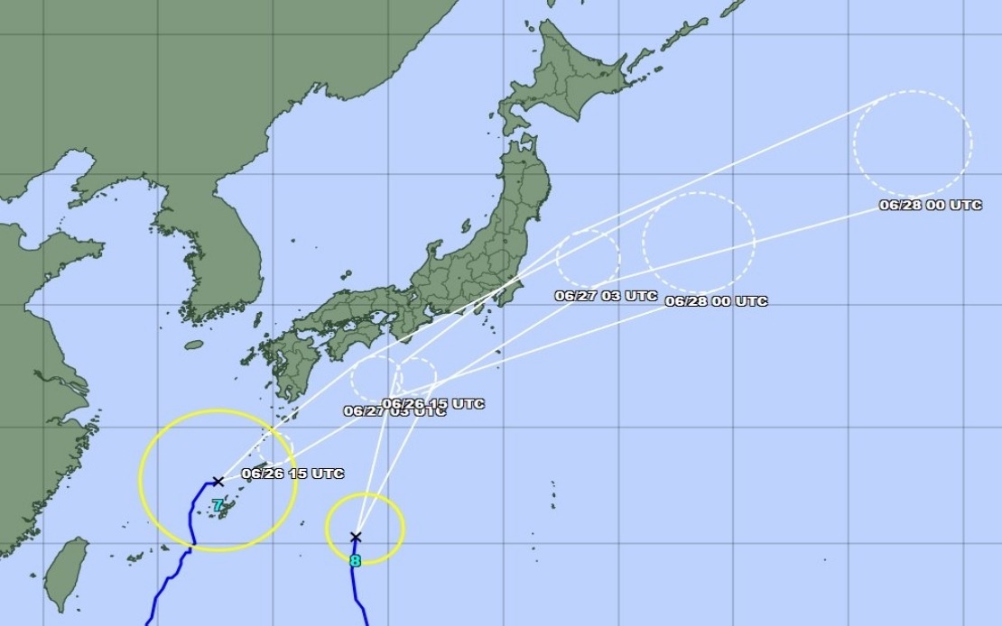
The compounded hazard scenario reflects a meteorologically unusual pattern where two separate cyclonic systems threatened to affect Japan nearly concurrently. Typhoon Mekkhala had already reached the Amami region in Kagoshima Prefecture by Friday morning, positioning itself to track toward the Kanto region inland the following day. Meanwhile, Typhoon Higos remained positioned offshore but was expected to make landfall Saturday, creating conditions where both systems could intensify precipitation across already-saturated terrain.
Authorities in Kyoto Prefecture issued the highest-level emergency alert for Seika town following a landslide that occurred Friday morning, underscoring how the extreme rainfall preceding the typhoons themselves had already triggered dangerous ground instability. The relentless precipitation over preceding days had saturated soil across southwestern Japan, creating conditions where additional heavy rain posed acute landslide risks independent of the typhoons' arrival. This sequential hazard pattern—where antecedent rainfall creates vulnerability for subsequent storm impacts—represents a critical consideration for Japanese disaster management, as ground conditions worsen progressively throughout extended wet periods.
Rainfall measurements preceding the typhoons already demonstrated exceptional precipitation intensity across multiple prefectures. Goto in Nagasaki Prefecture recorded 600 millimetres of accumulated rainfall between Tuesday and Friday morning, while Aso in Kumamoto Prefecture and Ureshino in Saga Prefecture each received in excess of 500 millimetres during the same period. Such accumulations, which approach or exceed typical annual rainfall for many temperate regions in a mere four-day span, had already saturated watersheds and soil profiles throughout Japan's southwestern territories.
The Japan Meteorological Agency expected both typhoons to lose their tropical characteristics and transition into extratropical cyclone systems as they approached and moved across the country. This transformation, while reducing sustained wind speeds, would not substantially diminish rainfall hazards, as the dissipating cyclones would interact with frontal systems and orographic lifting to maintain precipitation threats. The agency consequently urged continued public vigilance throughout the emergency period, as flooding and landslide dangers would persist even as traditional typhoon characteristics weakened.
Projected rainfall for the critical Saturday period posed particular concern for eastern metropolitan regions. The Tokai region faced forecasts of up to 300 millimetres by Saturday noon, while the Kanto-Koshin region was expected to receive up to 150 millimetres during comparable timeframes. The Tokai region, encompassing major industrial and population centers around Nagoya, faced especially intense precipitation prospects as both typhoon systems influenced moisture transport toward that area. The timing of convergent rainfall from dual systems concentrated within a narrow geographic band presented exceptional flood risks for river systems and drainage infrastructure across these densely populated zones.
Authority responses reflected recognition that conventional single-typhoon management protocols required adjustment when dual systems approached. The Fire and Disaster Management Agency coordinated evacuations across the Kinki and Kyushu regions, with 2.13 million residents under formal evacuation orders as of Friday morning. This represented an extraordinary mobilization of disaster response resources, requiring coordination across thirteen separate prefectural administrations and the national government to execute systematic withdrawal of vulnerable populations from flood-prone and landslide-susceptible areas.
Okinawa Prefecture braced for initial system impacts, with both typhoons tracking trajectories that would affect the southernmost Japanese territories first. As of Friday late morning, Typhoon Mekkhala was positioned northeast of Kume Island in Okinawan waters, moving northeastward at 15 kilometres per hour. This measured pace suggested gradual progression across the archipelago rather than rapid transit, potentially extending the duration of dangerous weather conditions across affected regions and requiring extended emergency resource deployment.
For Malaysian and broader Southeast Asian observers, Japan's dual-typhoon scenario offers instructive perspectives on meteorological hazard compounding and institutional disaster response coordination. While the Philippines and Vietnam periodically experience multiple tropical cyclones within single seasons, the simultaneous approach of two distinct systems to a single nation presents distinctive challenges for early warning systems, evacuation logistics, and emergency supply distribution. Japan's technological sophistication and disaster management maturity provide a comparative benchmark for regional preparedness standards, while the scale of required evacuations illustrates how even highly developed nations face extraordinary organizational demands during compound weather emergencies. The incident also underscores how climate patterns generating increased precipitation intensity and frequency heighten vulnerabilities across Asia's most densely populated regions, with implications for long-term infrastructure planning and disaster risk reduction investments throughout the broader Indo-Pacific.