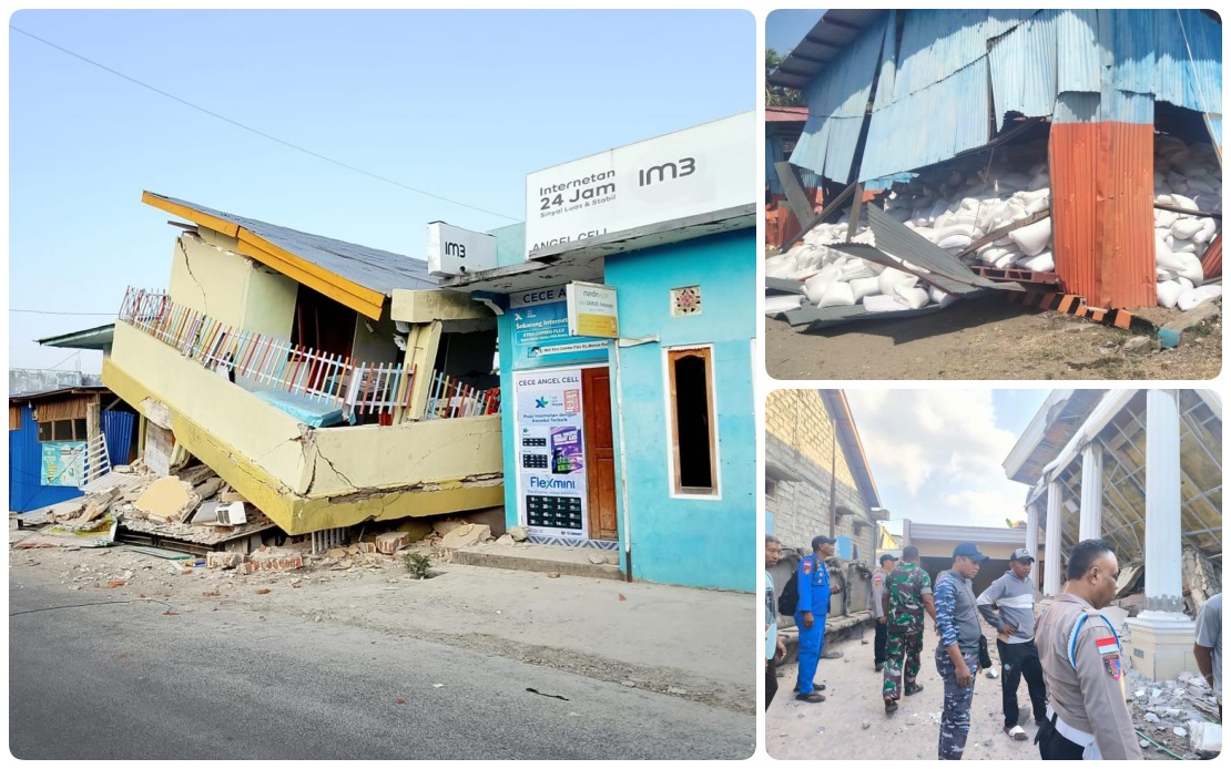
A devastating 7.7 magnitude earthquake has struck Indonesia's Flores Island, compounding the trauma of communities still haunted by memories of a catastrophic 1992 seismic event. The tremor, which occurred early Sunday morning at 4:58 am local time, originated in the sea approximately 30 kilometres from Mbay in Nagekeo district at a shallow depth of 15 kilometres, making it particularly destructive to surface structures and settlements. The impact has been severe and far-reaching across the region, with authorities continuing to assess the full extent of damage in the days following the initial quake.
The human cost has mounted to at least 53 confirmed deaths, with a further 135 people sustaining injuries across seven affected regencies and cities. Remarkably, national search and rescue officials report no persons currently listed as missing, suggesting that initial casualty figures may have captured most of the victims, though verification efforts remain ongoing. Deputy of Prevention at Indonesia's National Disaster Management Agency (BNPB), Abdul Muhari, acknowledged that authorities were actively updating casualty data as emergency response operations entered their second phase, indicating that the full picture of losses may still be incomplete.
What distinguishes this earthquake's aftermath is the relentless sequence of aftershocks that have continued to unsettle the region. The Meteorology, Climatology and Geophysics Agency (BMKG) recorded 995 separate aftershocks by Sunday afternoon, though only a fraction were strong enough for residents to detect. The psychological toll of these tremors cannot be underestimated, particularly given that many survivors carry vivid memories of the 1992 Flores earthquake and tsunami that devastated the same island. This historical context helps explain why approximately 9,290 residents had sought refuge at evacuation centres as of Saturday midnight, refusing to return to their homes despite efforts by authorities to restore normalcy and provide reassurance.
The earthquake triggered an immediate tsunami warning due to the submarine location of the epicentre, raising fears of a repeat of historical coastal disasters. However, careful sea-level monitoring by BMKG allowed officials to lift the tsunami alert by 7:31 am, indicating that ocean conditions had stabilised and no further significant tidal disturbances were anticipated. This rapid assessment and communication prevented additional panic, though the initial warning had already reverberated through communities accustomed to rapid evacuation protocols due to their exposure to natural hazards.
The earthquake's moderate depth of 15 kilometres, while not exceptionally shallow, meant that much of its energy was transmitted directly to surface infrastructure, causing widespread structural damage. Roads, buildings, and critical infrastructure across the affected zones sustained significant harm, with some areas completely severed from the regional network. One particularly troublesome section near Reok in Manggarai district experienced landslides that initially blocked passage even to essential fuel tanker trucks. Clearing this route became an early priority for recovery operations, as fuel supplies are critical both for emergency response vehicles and for powering generators in areas where electricity networks had been compromised.
Electricity restoration efforts have achieved some success, with power returning to several localities hit by outages. These early achievements demonstrate the capacity of Indonesian disaster response systems to prioritise essential services, recognising that communication, water treatment, and medical facilities depend on reliable power supply. The restoration work, however, remains incomplete, and authorities anticipate that rebuilding full electrical capacity will require sustained effort over coming weeks.
The National Disaster Management Agency has mobilised a comprehensive response infrastructure designed to address the immediate humanitarian crisis and prevent secondary disasters. Response coordination posts have been established in Labuan Bajo and Maumere, the two major population centres in the affected region, serving as hubs for information gathering and decision-making. Parallel logistics posts in Jakarta, Labuan Bajo, and Maumere ensure that relief supplies, specialised equipment, and trained personnel can be channelled efficiently to where they are most needed. This multi-layered approach reflects international best practices in disaster management and demonstrates Indonesia's institutional capacity to coordinate complex emergency operations across geographically dispersed areas.
Aircraft and helicopters have been placed on operational standby to support relief distribution and emergency evacuations if the situation deteriorates or if access becomes restricted due to additional geological disturbances. The positioning of aerial assets represents a strategic hedge against further complications, as Flores Island's topography and limited road infrastructure can make helicopter support invaluable when conventional transport routes are compromised. The readiness of these assets also signals to evacuated residents that authorities have contingency plans should new emergencies arise, potentially encouraging some confidence in the safety measures being implemented.
Current emergency operations are concentrated on three primary objectives: direct assistance to victims in the form of medical care and shelter; provision of food, water, and basic supplies to both affected residents and evacuees; and systematic assessment of structural damage to homes and public buildings. The third element is particularly important for determining the scope of long-term reconstruction and for identifying which buildings can safely be re-occupied. Many evacuees will remain cautious about returning until they receive formal clearance that their homes meet minimum safety standards, and this verification process cannot be rushed without undermining public confidence in official assessments.
For Malaysia and the broader Southeast Asian region, the Flores earthquake serves as a stark reminder of the seismic vulnerability that characterises much of the archipelagic and peninsular geography of the area. The Pacific Ring of Fire extends through much of Southeast Asia, subjecting the region to regular tectonic activity that occasionally produces catastrophic events. The effectiveness of Indonesia's response to this emergency, including rapid hazard assessment, evacuation coordination, and resource mobilisation, provides instructive lessons for other nations in the region that face similar geological risks and must prepare their own disaster management systems accordingly.
The lingering presence of nearly 1,000 aftershocks underscores the protracted nature of earthquake recovery. Unlike single-event disasters such as floods or storms, seismic activity can persist for months, with each minor tremor reinforcing trauma and delaying the psychological recovery of affected communities. Authorities acknowledge that this factor, combined with the historical weight of the 1992 disaster and the visible destruction of homes and infrastructure, creates formidable barriers to persuading residents to abandon evacuation centres prematurely. Patience, transparent communication, and sustained humanitarian support will be essential as Flores begins the long journey toward recovery.

