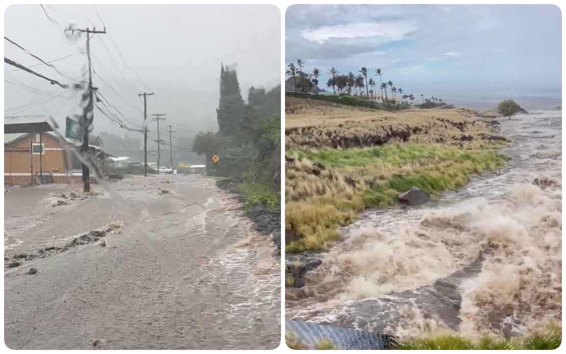
Hurricane Lala dealt a punishing blow to Hawaii on Saturday, August 15, as the tropical system moved through the islands with torrential rainfall and powerful winds that knocked out electricity for more than 88,000 customers and forced authorities to issue urgent shelter-in-place orders. The storm's track took it just south of Hawaii Island, the southernmost major island in the chain, where it unleashed its most severe impacts across residential areas and critical infrastructure.
Governor Josh Green reported that wind speeds were reaching their peak intensity on Hawaii Island while precipitation rates reached dangerous levels in some locations. Meteorological data collected during the storm's passage showed rainfall accumulations exceeding 13 inches in the hardest-hit areas, with conditions deteriorating across the broader region encompassing Maui County, Oahu and Kauai. The governor's assessment underscored the broad geographic scope of the disaster, which affected not just one island but multiple population centres across the Hawaiian chain.
The Hawaii Emergency Management Agency documented extensive damage from the storm's passage. Flooding inundated communities and coastal areas, while the high winds brought down large trees and damaged structures throughout the islands. Power outages cascaded across the electrical grid as infrastructure failed under the assault of sustained high winds and falling debris. The combination of these factors created hazardous conditions that prevented residents from leaving their homes safely and hindered emergency response efforts.
According to Hawaiian Electric Company, the utility serving the majority of Hawaii's population, the power cuts were distributed unevenly across the islands based on the storm's intensity. Hawaii Island bore the brunt of the electrical disruptions, with 63,270 customers in the dark as of 7 p.m. local time. Maui County, which includes Maui, Molokai and Lanai, experienced approximately 15,260 outages, while Oahu, home to the state capital Honolulu and the most densely populated island, reported roughly 9,500 affected customers. The disparities in outage numbers reflected both the uneven distribution of the storm's path and variations in infrastructure vulnerability across different regions.
Visual documentation of the disaster emerged from footage captured by Hawaii's Department of Transportation, which showed streams overflowing their banks and inundating roadways. These images provided stark evidence of the precipitation rates and flooding severity that residents endured during the storm's peak hours. The transportation agency's records revealed a pattern of systematic infrastructure failure as multiple major routes became impassable in the hours following the storm's arrival.
Highway closures proliferated across three major islands as the storm progressed. Transportation officials documented that roads on Hawaii Island, Maui and Oahu all sustained damage severe enough to warrant closure, disrupting normal traffic patterns and limiting evacuation routes for residents in affected areas. The Department of Transportation issued explicit guidance for residents to shelter in place rather than attempt travel on compromised roadways, recognizing that venturing outside during the storm posed greater danger than remaining indoors despite hazardous conditions.
Local law enforcement agencies reported widespread disruption across Hawaii Island's communities. In Mountain View, a residential neighbourhood on the eastern side of the island, floodwaters forced the closure of Kahikopele Street, trapping residents and preventing access to nearby properties. The impacts extended to Pauahi Street, where flood damage similarly disrupted normal passage. Along Mamalahoa Highway, a critical north-south corridor on Hawaii Island, emergency responders documented numerous fallen trees and accumulations of large debris that created driving hazards. The closure of Plumeria Street resulted specifically from downed power lines that created electrical hazards and blocked vehicle access.
Wind speeds recorded during the storm's peak proved catastrophic for Hawaii Island's electrical infrastructure. Anemometer readings documented wind gusts approaching 90 miles per hour in several locations across the island, providing the physical explanation for the widespread power outages. These extreme winds toppled trees that fell onto power transmission infrastructure, with fallen timber bringing down multiple utility poles and structural supports. The damage extended across a 42-mile stretch of transmission lines on the Hamakua coast, a remote and rugged area on Hawaii Island's northeast side where damage assessment and repair work would prove particularly challenging.
Hawaiian Electric officials indicated that restoration efforts would necessarily proceed slowly given the hazardous conditions persisting across the islands. For customers already experiencing power loss on Hawaii Island and Maui, the utility warned that electricity would remain unavailable at minimum through the following morning. The dangerous wind conditions and continuing precipitation that accompanied the storm's passage prevented line crews from safely deploying to assess damage and begin restoration work. This meant that hundreds of thousands of residents faced an extended period without air conditioning, refrigeration, lighting and other electrical services essential to modern life.
The scale of Hurricane Lala's impact on Hawaii carries broader significance for understanding tropical cyclone risks across the Pacific. As an island state situated in a region prone to hurricane formation, Hawaii faces recurring threats from these powerful storms despite its relatively sheltered position in the central Pacific. The infrastructure damage and population disruption caused by this single system underscore the vulnerability of island communities to severe weather events, a concern that resonates across Southeast Asia and the broader Indo-Pacific region where similar tropical cyclone threats persist seasonally.

