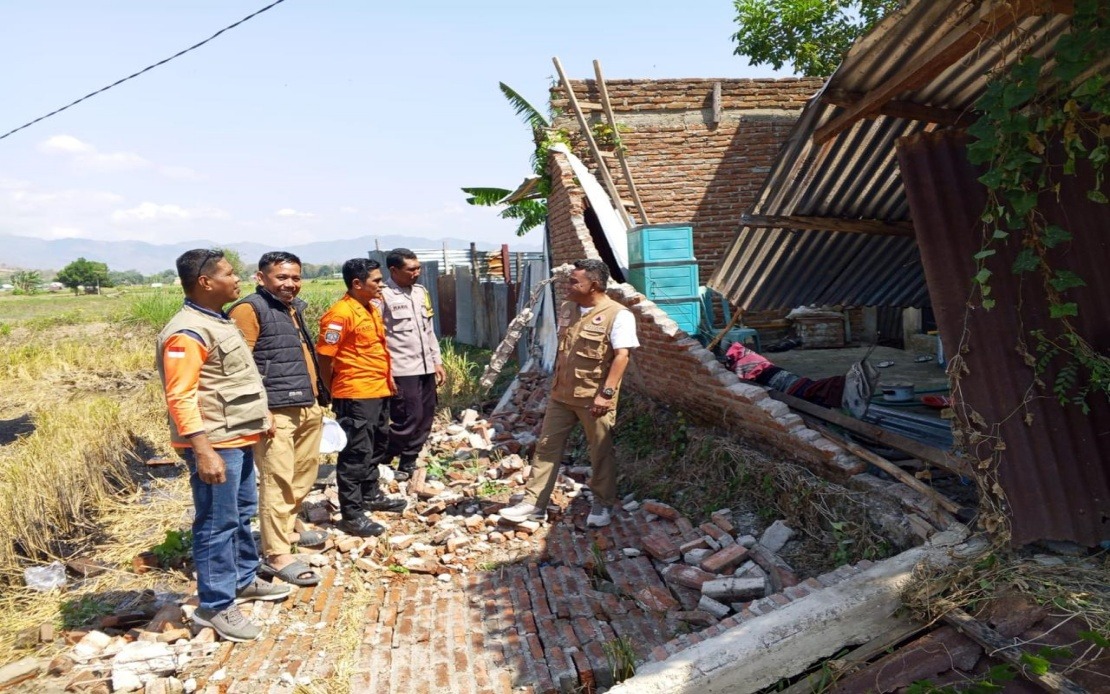
Indonesia's Flores Island in East Nusa Tenggara province experienced a devastating earthquake early Saturday morning that forced the mass evacuation of roughly 2,000 residents to safer ground. The magnitude 7.7 tremor, which struck at 4:58 am local time with its epicentre located approximately 30 kilometres from Mbay at a depth of 15 kilometres in the sea, triggered immediate emergency responses from authorities and prompted residents to seek shelter independently. The scale of the displacement highlights the vulnerability of communities in this seismically active region and the speed with which natural disasters can uproot populations across the archipelago.
Following the main quake, Indonesia's Meteorology, Climatology and Geophysics Agency (BMKG) issued a tsunami warning that remained in effect for roughly two and a half hours before being lifted at 7:31 am, once sea-level monitoring indicated that no dangerous waves were developing. According to Berton Suar Pelita Panjaitan, the acting chief of the National Disaster Management Agency's (BNPB) Disaster Data, Information and Communication Centre, the combined force of the earthquake and the subsequent tsunami alert motivated most residents to evacuate their homes either through official channels or by their own initiative. This rapid response mechanism, though reflective of community awareness following years of seismic activity, underscores the constant state of preparedness required in earthquake-prone zones.
The death toll from the earthquake and the numerous powerful aftershocks has reached 20 according to the Maumere Search and Rescue Office, with an additional six people sustaining injuries and two others remaining trapped in the rubble. These casualty figures, while preliminary, reveal the direct human cost of geological events in populated areas. The scale of injuries and trapped individuals suggests that rescue operations continued throughout the day as emergency teams worked through debris across multiple affected communities.
Structural damage assessments conducted in the immediate aftermath revealed a concerning pattern of destruction across the region. The BNPB documented that 54 residential structures suffered severe damage, with nine experiencing moderate damage and 11 sustaining minor harm. Beyond homes, critical infrastructure sustained significant impacts, including five health facilities, one educational institution, three places of worship, one warehouse operated by state food logistics agency Bulog, and six government offices. These losses extend the disaster's consequences beyond immediate shelter concerns to encompass public health capacity, educational continuity, and governmental functions essential for recovery operations.
Manggarai district emerged as one of the most severely impacted areas, with preliminary reports indicating that 29 houses experienced severe damage alongside nine moderately damaged structures and nine with minor damage. The adjacent East Manggarai district recorded 23 severely damaged houses, suggesting that the earthquake's intensity varied across the island's geography or that certain areas bore particular vulnerability based on construction standards and soil composition. These two districts, representing the epicentre's proximate zones, faced the most immediate reconstruction challenges and the highest concentration of displaced families requiring humanitarian assistance.
The national disaster management agency acknowledged during Saturday's official statement that comprehensive impact assessments were still underway across the affected territories. Representatives emphasised that impact data collection, verification, and validation processes continued at ground level as various stakeholders compiled information. This measured approach, while necessary for accuracy, meant that final damage tallies and full casualty accounting would emerge only after systematic surveys were completed, a reality that delayed complete understanding of the disaster's scope but ensured subsequent response efforts would be grounded in verified information.
The earthquake's reach extended into the critical realm of telecommunications infrastructure, with significant consequences for affected communities' ability to coordinate rescue efforts and maintain contact with family members. By 7 am Saturday, the Communication and Digital Affairs Ministry identified disruptions across 200 base transceiver station sites distributed throughout 10 districts and cities across East Nusa Tenggara province. Digital Infrastructure director-general Wayan Toni Supriyanto noted that these affected sites represented approximately 16.35 per cent of all BTS infrastructure in the impacted regions, a substantial loss that impaired both official emergency communications and ordinary residents' capacity to reach loved ones.
Response coordination involved the full spectrum of Indonesia's emergency management apparatus, with the BNPB statement confirming that regional disaster management agencies, military units, police forces, local government administrations, and auxiliary organisations worked in concert to assess damage, verify casualty statistics, monitor developing conditions, and address humanitarian needs among displaced populations. This multi-agency approach reflects standard Indonesian disaster protocols, where decentralised provincial structures coordinate with national-level direction to mount comprehensive responses. For Malaysian and Southeast Asian observers, the scale of Flores's institutional mobilisation demonstrates both the region's accumulated experience managing seismic disasters and the organisational complexity required when natural events strike populated areas.
The 111 aftershocks recorded in the quake's immediate aftermath represented a significant secondary hazard that extended evacuation necessities and complicated rescue operations. These sustained tremors, which continued well beyond the initial main shock, kept residents in a state of heightened alert and prevented hasty returns to damaged structures that might experience further collapse. The psychological impact of prolonged seismic activity compounds the physical trauma of displacement, affecting both rescue workers' operational capabilities and survivors' emotional resilience during what becomes an extended emergency phase rather than a discrete event.
For regional observers across Southeast Asia, the Flores earthquake serves as a potent reminder of the tectonic realities shaping the Indo-Pacific region's geography and human settlement patterns. Indonesia's position along the Pacific Ring of Fire ensures that such events occur with sobering regularity, making continuous investment in early warning systems, building code enforcement, and disaster preparedness training essential components of national development strategy. The evacuation of 2,000 residents, while representing effective emergency response, also underscores the ongoing challenge of protecting dense populations in seismically volatile zones where geological forces operate on timescales beyond human control.

